Wednesday, February 24, 2016

NO. 6 (Read in this order) Mysteries of History Revealed Part 1 Chapter 1 Pages 22-32.

To order book send $!5 for one or $30 for both to Jeremy Auldaney, 3410 La Sierra Ave. - F255, Riverside, CA 92503. Or order from Amazon Books search for Auldaney.


DINOSAUR DEPOSITS CONTAIN SALT FROM THE OCEAN
Owl Rock Member of the Chinle Formation consists of pinkish-orange mudstones (Note: Feldspar) mixed with hard, thin layers of limestone. Lenses of selenite gypsum are scattered periodically throughout the Owl Rock Member representing the minerals left behind after evaporation of inland lakes from marine salt water incursions.

 The photo above shows the different Formations: Navajo, Kayenta, Wingate all Early Jurassic, Chinle Upper Triassic, Moenkopi Lower Triassic. All this sandstone is crossbeded by changing currents of water and contain only pristine tracks of dinosaurs and unidentified reptiles and ripples and mud cracks on temporary surfaces. These animals are often being pushed by currents sideways from their direction of travel. These are identical to supposed older Permian tracks of supposed unidentified reptiles, and the evidence indicates they are part of this same formation missdated by evolutionists. Notice the flat layers without significant erosion. Only the Chinle contains body fossils freshwater clams as steinkerns (internal molds) of freshwater bivalve shellfish called Unio clams and petrified bones dinosaurs and other reptiles. I have found many of these near Tuba City.

This is typical Chinle Formation which often forms mounds of unconsolidated volcanic mixed water deposited sediment colored by iron and other volcanic minerals called montmoritllonite or bentonite. It contains a few body fossils unlike the crossbeded sandstone above it which contains only pristine trackways.

www.shroomery.org › ... › Mushroom Cultivation‎ Dec 3, 2011 - 4 posts - ‎1 author. One of the by-product of salt is gypsum crystals, a marine evaporite. ... the formation of this crystal is from the evaporation of salt water.

The National Park Service published a paper CONTINENTAL TRACE FOSSILS, PETRIFIED FOREST NATIONAL PARK: TOOLS FOR PALEOHYDROLOGIC AND PALEOECOSYSTEM RECONSTRUCTIONS Stephen T. Hasiotis Department of Geological Sciences University of
Colorado Campus Box 250 Boulder, CO 80309-0250 And Russell F. Dubiel U. S. Geological Survey Denver, CO 80225-0046

“These inland lakes were left behind when the oceans covered the land leaving behind mineral evaporates like gypsum, and salt.

“Continental trace fossils (Note: ichnofossils or tracks) from the Petrified Forest Member of the Upper Triassic Chinle Formation in Petrified Forest National Park (PEFO), Arizona, were made by beetles, termites, soil arthropods, horseshoe crabs, and crayfish.”

Wikipedia says,

Horseshoe crabs (family Limulidae, order Xiphosura or Xiphosurida) are arthropods that live primarily in and around shallow ocean waters.”


When I was in the Petrified Forest I discovered a piece of gypsum, which I recognized because I had found a lot of it in Orange County Miocene fossil sites which were marine. This indicated to me the ocean had been here when these logs were deposited. Then I heard that a horseshoe crab fossil had been found in the Petrified Forest which confirmed my suspicions.

Here is interesting information that indicates the Petrified Forests are massive Flood deposits.

www.geo.mtu.edu/  This is from a research project from Michigan Technological University

“You measured and described one gypsum layer. There are five more gypsum layers within the Michigan Formation in this area.
These are salts. If a 1000' deep ocean in an arid area were to completely dry up, it would precipitate about 16' of evaporates.

It will precipitate gypsum when enough water has evaporated to reduce it to 1/3 its original volume. Sea water reduced to 1/10 its original volume will precipitate halite (Note: Salt crystals). If sea water evaporates completely, 83% of the precipitated evaporates will be halite (NaC1), 4% will be gypsum and the remainder will consist of other evaporates.”

USGS on line data tells us about the Mississippian ‘age’ Michigan Formation referred to above:

“Thicknesses of 91 to 122 m are more typical. Although generally composed of greenish gray and dark gray shale, this formation is lithologically variable and includes discontinuous beds of sandstone, limestone, dolostone, gypsum, and anhydrite. One of these carbonate beds, called the "Brown Lime," is a 3- to 6-m thick dolostone that can be traced in the subsurface across much of the basin.”

This evidence proves a lot of hot volcanic ocean water covered the land and evaporated leaving mineral salts behind.
Kansas Geological Survey, Geology
Placed on web July 24, 2009; originally published February 1978
“The Hutchinson Salt Member of the Permian Wellington Formation… Thickness of the salt reaches a maximum of 555 feet in northwestern Oklahoma.” 
FLOOD/POST-FLOOD UNCONFORMITY
Returning to the Arizona Petrified Forest let’s look at the Post-Flood Bidahochi Formation found on top of the Flood deposited Chinle Formation described in the National Park Service brochure. This was deposited after the Flood in lakes left behind by the receding ocean water:
“During the Late Miocene and Early Pliocene Epochs of the Neogene Period (4-8 million years ago) a large lake basin with ephemeral lakes covered much of Northeastern Arizona. Fine-grained fluvial (flowing) and lacustrine (lake related) sediment such as silt, clay, and sand represent the lower part of the Bidahochi Formation. Volcanoes, both nearby and as far as the Southwestern Nevada Volcanic field, spewed ash and lava over the land and into the basin. Many of the volcanoes were phreatomagmatic, when ground or lake-water mingled with eruptive material (magma) to cause explosive eruptions.”
 This is an illustration of the huge lake left behind after the Flood of Noah which produced a Post-Flood layer on top of the Flood layer.
This is how that layer is found on top of the Flood boundary unconformaty in Arizona.  There is 192 million years missing between these two layers. Do you see a lot of erosion? Where are the Grand Canyons?
This is describing the Post-Flood volcanic upheavals on top of the Flood deposits. The deposits below are mostly rhyolitic and colorful, and those on top after the Flood are tan or grey basaltic ash.

Most of these petrified fossil sites are created by rhyolitic magmas at the beginning of the Flood upheaval, which have higher gas and water content than basaltic magmas which contain more iron and thus rhyolitic lava is more explosive since gas under pressure is kept as a liquid deep in the earth, then explodes into a gas as it nears the surface. The rainbow colors of most Flood created fossil sites and the most typical of this is the Morrison dinosaur Formation, indicate these were violent rhyolitic eruptions.
A rare rhyolitic volcanic caldera today is found at Lake Taupo, in the centre of New Zealand’s North Island. This huge volcano has produced two of the world’s most violent eruptions in geologically recent times. This supports the conclusion that eruptions just before and during the Flood were much more explosive than those today. Rhyolitic eruptions are common in the fossil record, but rare in Post-Flood historical times. I believe this is evidence that they were part of the fountains of the deep, when the earth had much more water stored inside it than it does today, and the lava came from shallower chambers beneath the surface.
Only three eruptions of rhyolite have been recorded since the 20th century—the eruptions were at the St. Andrew Strait Volcano in Papua New Guinea, Novarupta Volcano in Alaska United States, and Chaiten in Southern Chile.

MISSING STRATA IN THE PETRIFIED FOREST

Between the Bidahochi Formation and the Chinle Formation there is 192 million years of missing strata, if evolution were true. However, the contact shows an unconformity contact that is rough showing it was a surface, but is almost level compared to canyons and rivers today. The large valleys like the Grand Canyon itself formed by erosion in this area were all formed more recently long after the Flood by huge amounts of moving water from huge lakes through breached damns, long after all the flat rock strata had been deposited during the Flood event. We see nothing like these canyons and valleys in the geologic record. So the present is not the key to the past, or does it show the 192 million years does not exist?


The Geological Society of America Bulletin - Isotopic age of the Black Forest Bed, Petrified Forest Member, Chinle Formation, Arizona: An example of dating continental sandstone  By N.R. Riggs, S.R. Ash, A.P. Barth, G.E. Gehrels and J.L. Wooden Accepted 17 April 2003.
“Volcanic detritus in the Chinle Formation was derived from multiple, distinct sources. Coarse pebble- to cobble-size material may have originated in eastern California and/or western Arizona, where Triassic plutons are exposed. Fine-grained detritus, in contrast, was carried in ash clouds that derived from caldera eruptions in east-central California or western Nevada.”
This was a very large explosive volcanic eruption when water explodes into steam. Some of these volcanoes were probably in our Mojave Desert where there are lots of recent volcanoes and black basalt flows. They were caused by the movement of the continents away from the mid Atlantic Ridge during and for many ears after the Flood, the Bible’s description matches the Mid Atlantic Ridge as part of the fountains of the deep. Many of these volcanoes that erupted during the Flood started erupting after the Flood, in the Cenozoic into the Pleistocene about the time of Babel and Peleg approximately 2500 BC and caused mountain chains to rise again after being eroded as the Flood receded.
 This is one of the many basaltic Pleistocene volcanoes in the Mojave desert. There were mammoths and bison antiquis and Clovis people living here when they erupted during Peleg's division.
 This is one of the volcanic craters formed by underground water explosions during Peleg's division and plate subduction around the ring of fire in the Pacific ocean. I hiked down to the bottom and found an artifact, a pistil used in mortars to grind seeds by natives. I thought that it might be a misidentified meteorite crater. But it served to prove objective science. I found no meteorites like at Odessa Texas and Meteor Crater Arizona. Only evidence of volcanic minerals and one out of place granite rock pestle.
Now you might say maybe there were several eruptions over millions of years. Well then where are the unconformities containing canyons and river valleys between these layers? There are no unconformities in Chinle, much less canyons like we see in the present surface, except the minor one between the Bidahochi and the Chinle! In the Chinle there are only changes in color. The unconformity above the Chinle is because the Bidahochi is a Post-Flood formation, when breached dams of huge Pleistocene inland lakes caused flooding over about 100 to 1000  years after the Flood, forming the Post Flood Grand Canyon in strata formed during the Flood.


Lucchitta, 2001. Hiking Arizona's Geology, Hike 11, Coliseum Diatreme, pp. 116-119, p. 117 explains:
“The Pliocene to Late Neogene Bidahochi Formation, lies at an elevation of about 6,300 feet (1,920 m) to 6,600 feet (2,012 m) at the southeast of the Colorado Plateau; the deposits are from Bidahochi Lake, (also called Hopi Lake), and the deposits extend southwards to the region at the north perimeter of the White Mountains of central-east Arizona. Bidahochi Lake is thought to have been a single "large lake, or several shallow, and ephemeral ones."] Various fossil types are found; also bird trackways.”

This type of deposit is common for the Post Flood as the salty marine water receded; it left huge salty lakes, which lasted hundreds of years being kept full by huge torrential post Flood rains, which secular archaeologists call the pluvial period. Fossil leaves, fish, reptiles, freshwater shellfish, birds, bird tracks, and feathers are common in this type of limy shale. This deposit is similar to Orange County Miocene, and the Eocene Green River Formation in Wyoming, and one in Lebanon. I have found all of these to be incorrectly dated and are all part of the Post-Flood Period and could all be considered Pleistocene. In Florida the bones of Pleistocene camels, etc. are mixed with Miocene sharks, whales, and marine shellfish that are supposed to be millions of years older.

The Chinle appears to be one continuous event with only a little erosion, not 192 million years separating it from the Bidahochi.

PROOF GRAND CANYON IS RECENT

Even the Grand Canyon was formed during the recent Pleistocene according to secular geologists. Hopi Lake or Lake Bidahochi, mentioned above was the one that breached its damn and formed the Grand Canyon in weeks not millions of years as it cut its way to the Gulf of Mexico some time after the Flood. Of course the canyon has nothing to do with the age of the strata in the canyon, which evolutionists say started forming during the Pre-Cambrian, supposedly 2 billion years ago. Evidence of flat strata with no major erosion surfaces indicates it was one event, or events not far apart. Proof from secular geology that the formation of the canyon is a separate event is given below, and is not part of the ancient strata it cut through. It describes the breached damn which formed the canyon.
Price, L. Greer (1999). Geology of the Grand Canyon. Grand Canyon, Arizona: Grand Canyon Association. ISBN 0-938216-68-6 Page 58.

“From 5.5 million to 5 million years ago, headward erosion to the north and east consolidated these streams into one major river and associated tributary channels.” Then they started to down cut forming the canyon.

This is Lake Bidahochi. Of course there are some evolutionists who don't want to give up the millions of years for the formation of the Grand Canyon and claim this lake was only a shallow ephemeral lake. But they cannot deny that a large canyon like the Grand Canyon does not form by a little water over a long period of time. It would form a shallow ditch not a wide canyon.

Evolutionists always try to explain their way out of evidence against their theory; they claim it took a little water a long time to cut the canyon; however, when a breached damn happens it produces a canyon rapidly.

The deposit it made during the cutting of the canyon is found in the lower Colorado trough in the Gulf of Mexico which is called the Bouse Formation found in Arizona, California, and Nevada. Most of this deposit is in the Anza Borrego Desert. It contains Miocene/Pliocene freshwater mollusks, similar to Orange/Los Angeles County’s Miocene deposits.This deposit spilled over into the Los Angeles/Orange County basin.
 This is the Pleistocene Bouse Formation produced by the run off of sediment from the Grand Canyon going from Wyoming to the Golf of Mexico after the Flood of Noah during the Pleistocene during the breached damn period. And it contains no dinosaurs or other Flood deposits, only Post-Flood Pleistocene mammals at the time of Peleg's Division.
Here is a map of Pleistocene mammal and marine deposits. The marine Imperial Formation is found in much of Southern California.

When paleontologist Dr.Robert E. Reynolds of the San Bernardino County Museum led us on a field trip to the Bouse Formation in Nevada he took us to a small museum which had bones from a Pleistocene elephant on display from the Bouse Formation found in gravel. The biggest mystery he told us was, geologists were puzzled by the fact that most of the alluvium from the Grand Canyon was missing! The Bouse Formation was pitifully small and it did not contain dinosaurs.

Another mystery is how the river cut through the Colorado plateau which is higher ground. This is also true in other places like the Santa Ana River going from Riverside to Orange County in California cutting through the Santa Ana Mountains. Since we know that some mountains rose after the flood during Peleg's Division from geologic observation and evidence when the flood water left the dry land from the creation viewpoint, it appears that the runoff cut down through mountains and plateaus or blocks of rising land as they rose during and after the Flood. This may have taken hundreds of years of runoff, and included occasional flash floods from breached damns from lakes of trapped ocean water, and glacial melting through soft volcanic ash.

I have observed slickensides (rock cracking and sliding under pressure producing slick polished surfaces) in all forms of rock, which sometimes contain lava flows show the mountain forming orogeny upheavals were huge mega earthquakes, and not slow movements of rising mountains over millions of years. Also, rocks bend like plastic before they harden into solid rock, and this also happens when solid rocks are moved slowly, only rapid movement of solidified rock cracks them with slick surfaces. It is said that they are fault polished rock, but I have seen them in all rocks, not just near faults. Slickensides do not form slowly.
This is a picture of a slickenside where rock has slid over rock as mountains were upthrust after the Flood.
All over Riverside, California I have observed cracks in the granite that are filled with lighter colored rock that filled in the cracks. This light colored rock is quartz which hardens slower at lower temperatures than the surrounding granite. These intrusive quartz veins could not form slowly over millions of years or they would not remain hot enough to flow into the cracks and then they would form crystals. This is the same granite found in the mountain barriers in California. Evolutionists claim the granite is Jurassic, actually all granite is basement rock created during creation week, then it got upthrust during the Flood when the Mesozoic strata was deposited, and again after being eroded flat as the Flood receded, rose again after the Flood and during another catastrophic event or events.

During my research into the writing of the paper on the asphalt seeps at La Brea I discovered that the Miocene and Pleistocene sediment was upwarped along the Santa Monica Mountains as they rose. There are mountain barriers the length of California separating the higher deserts from the coastal plane.

HUGE FLOODS FROM DESERT LAKES INTO COSTAL CALIFORNIA

I have observed masses of loose sand, rocks, and boulders sorted all along
the mountain barriers called the Santa Ynez Mountains, the Tehachapi Mountains, the San Gabriel Mountains, the San Bernardino Mountains, the San Jacinto Mountains, and the Santa Rosa Mountains. The rocks are sorted from large to small determined by their distance and speed of the flowing water that deposited them. Many are huge boulders requiring huge amounts of rapidly moving water coming from the Mojave Desert that appears to have been a huge lake at one time.


MOST FOSSIL ANIMALS WERE BURIED ALIVE!
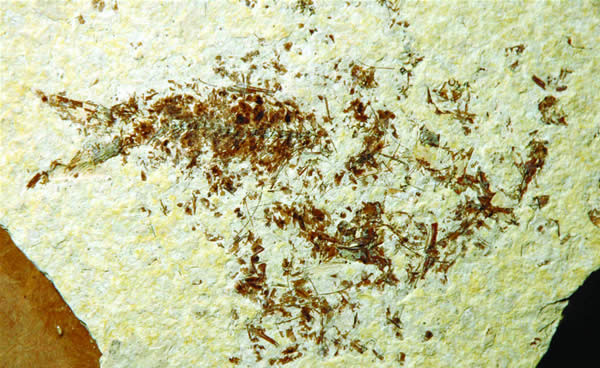
Some fossils like the Flood deposited Jurassic Berlin Archaeopteryx show they were alive when they fell into this bentonite (volcanic ash mixed with water altered sediment) mud which turned into shale similar to the Post-Flood California and Wyoming fossil fish beds, moving its wings, leaving movement smear lines in the feather impressions near the muscles in the shale.

In the Gobi desert Cretaceous strata, a small Veloceraptor dinosaur was found entangled with a Protoceratops dinosaur, actively fighting when they were buried alive.

The discovery of these dinosaur nests created the false myth that the Veloceraptor was an egg predator, thus, the name, “Egg Stealer.”
Paleontologists have made a lot of gross errors. But there is one thing that the evolutionists will swear too that can never be falsified – evolution is a fact of science! When facts conflict, with theory; they support the theory. The eggs turned out to be Veloceraptor!
Veloceraptor nest.
Polygamy, Paternal Care In Birds Linked To Dinosaur Ancestors...
www.sciencedaily.com/releases/2008/.../081218141734.ht...
Science Daily Dec 19, 2008 - Sure, they're polygamous, but male emus and
several other ground-dwelling birds also are devoted dads, serving as the sole incubators... Science News Dec. 19, 2008 gives us a fascinating look into the past in their article, from a paper, written by paleobiologist Gregory M. Erickson above of The Florida State University and other researchers writes,
"In those cases where adult dinosaurs have been found on top of nests, we found that the volume or mass of the egg clutch (total number of eggs in the nest) is very large relative to the size of the nesting animals." 
Notice the evolutionists are interested in their theory of polygamy, and ignore the more significant fact that these dinosaurs were buried alive sitting on the nest! This fact indicates that all dinosaurs worldwide were buried alive!!

These so called nesting sites are made up of common crossbeded red sandstone in Formations called: Navajo, Moenkopi, Coconino, etc. each of which covers thousands of square miles in areas that are found spotted around the world. This same crossbeded red sandstone commonly contains fossilized tracks, dated from the Permian to the Cretaceous and are falsely claimed to be wind blown sand deposits because they have ripples created by flowing water and they are cemented by volcanic silicon which could never happen in a desert sand.

Several ichthyosaur marine reptiles have been found fossilized in the act of giving birth. Dave Smith geologist working in artwork/design and paleontology for the University of California Berkeley Museum of Paleontology, writes in November 7, 2005,
“Rare fossils have been found that show ichthyosaurs actually giving birth to live, well-developed young; ichthyosaurs never had to leave the water to lay eggs. In fact, from their streamlined, fishlike bodies, it seems almost certain that ichthyosaurs could not leave the water. Yet they still breathed air and lacked gills, (they were) like modern whales.”


 This is a mother Ichthyosaur giving birth while being suffocated by volcanic dust. You can see the Fallopian tube in which the baby is being born tail first unlike most reptiles which use eggs.

They are a form of reptilian porpoise. In fact they may have been warm blooded, this would explain how the Loch Ness plesiosaurs can survive in cold water.
Some of these ichthyosaur fossils have recently born babies swimming above the mother, indicating these marine reptiles were slowly suffocated by settling volcanic mud, probably from rock pulverized in explosive volcanic eruptions into fine grained sediment. One was even found giving birth, with the baby coming down the fallopian tube, tail first. The flesh of the fallopian tube and the skin around the ichthyosaur can be seen faintly as a stain in the shale!

X-ray examinations of Devonian slates has shown that soft parts of trilobites have been preserved in the shale, but are invisible to the naked eye!

Un-flattened three dimensional Ordovician Calymene trilobites are commonly found coiled like pill bugs, indicating burial alive while under stress. Trilobites in limestone are usually un-flattened in a living position, un-like the commonly flattened fossils in shale and slate.
 This is a coiled Phacops Rena trilobite prepared for danger which is commonly found.
This is the same animal as it is found normally as a three dimensional fossil in limestone, unlike the flattened ones in shale.

Also, (I know this from personal observation of hundreds of thousands of trilobites) Cambrian trilobites in Utah and the Mojave Desert are usually only complete parts of exoskeletons. Heads (cephalons), main body (thorax), rear end (pygidium), or just their cheeks (genal lobes). And these are sometimes sorted by size. Some parts of the trilobites at Antelope Springs Utah, Marble Mountains in the Mojave Desert California, or from Canada are sorted so only heads or tails can be found in certain areas of the site. At Antelope Springs, Utah I also found different trilobite species were sorted into different areas. Elrathia kingi, and Asaphiscus are the most common at the main quarry area at this site. A mile away Peronopsis, Bathyuriscus are common. This shows sorting by moving water and fine mud.

To support this ministry of truth order my books Mysteries of History Revealed Part 1 and Part 2. Order from Amazon Books at (if it doesn't link, copy and paste in Search Engine) http://www.amazon.com/Mysteries-History-Revealed-Part-Meteorite/dp/1511515457/ref=sr_1_1?s=books&ie=UTF8&qid=1456342556&sr=1-1&keywords=auldaney 

Or get half price (FREE SHIPPING) mail $15 for one or $30 for both to Jeremy Auldaney, 3410 La Sierra Ave - F255, Riverside, CA 92503.  Or order from Amazon with debit or credit card: http://www.amazon.com/Mysteries-History-Revealed-Part-Meteorite/dp/1511515457/ref=sr_1_1?s=books&ie=UTF8&qid=1456863199&sr=1-1&keywords=auldaney


Tuesday, February 2, 2016

NO. 5 (Read in this order) Mysteries of History Revealed Part 1 Chapter 1 Pages 11-22.


Part 1 Chapter 1 Pages 11-22.


KT BOUNDARY IMPACT PRODUCED VOLCANIC ERUPTIONS

Secular scientists ruled out their previous belief that the KT Boundary was caused by a worldwide volcanic upheaval, but rather an asteroid impact. They are wrong. The fact is it was not the asteroid impact that caused the extinction of the animals. It was only the trigger according to observations of the fossil and geologic record. And the Bible says it involved a Flood.


This is in Trinidad Lake State Park in Colorado one of the best exposures of the K/T Flood Boundary. The site may be visited by taking a short hike down into Long Canyon.

The Cretaceous boundary was when 75% of all living species, including dinosaurs became extinct, excluding mammals. Most scientists today believe that a giant asteroid crashed into earth in the Gulf of Mexico, creating a nuclear-winter type of event that killed most animals and plants living at that time.  This belief is based on the presence of iridium, shocked quartz and microtektites found in the sedimentary layer dated  by creation scientists to approximately 2348 BC, and found in about 100 localities around the world.  This layer is termed the K-T layer (Cretaceous-Tertiary layer).

There was a lot of speculation on why some animals survived and others did not for many decades since Darwin. Till now most evolutionary paleontologists had given up trying to identify the cause of extinctions. They had dozens of theories, including ridiculous ones like dinosaurs died of diarrhea, or swallowing gastroliths, or eating newly evolved poison plants, or flowers giving off pollen, thin egg shells, evolving new mammals, etc. When man wants to believe something desperately enough he will make up the most ridiculous ad hock speculations. Man examines and attacks symptoms, rather than the cause that is in plane sight. This happens in the medical field, in politics, and science.

Here are quotes from:

1. Schulte, P.; Alegret L.; Arenillas, I; Arz, J.A.; Barton, P.J.; Bown; P.R.; Bralower; T.J.; Christeson, G.L. el al. (5 March 2010). "The Chicxulub Asteroid Impact and Mass Extinction at the Cretaceous-Paleogene Boundary". Science 327 (5970): 1214-1218. Bibcode 2010Sci...327.1214S. doi:10.1126/science. 1177265. PMID 20203042.

2.  Keller, G. (2012). The Cretaceous --Tertiary Mass Extinction, Chicxulub Impact, and Deccan Volcanism. Earth and Life, Springer: 759--793.
“The fact that the extinctions occurred at the same time as the impact provides strong evidence that the K-Pg extinction was caused by the asteroid.[1] However, some scientists continue to argue that other factors, such as volcanic eruptions,[2] climate change, and/or sea level change, caused or at least contributed to the extinction.”
These scientists are right, it was not the impact that killed the dinosaurs, or the darkened skies, but the massive worldwide volcanic eruptions with choking fine silicon dust and gases, followed by the release of subterranean waters flooding the earth causing the oceans to raise that killed the dinosaurs. Of course this was followed by sudden permanent changes in the weather and loss of plants and animals in the food chain.
Geologists/paleontologists have argued weather the Iridium came from an asteroid or from volcanic eruptions. I have said all along, it came from both sources! What would cause worldwide massive eruptions? The only cause we know of is asteroid impacts. Of course there are ad hock theories that the center of the earth heated up through atomic chain reaction, but there is no evidence to support this, and what would trigger it?

DINOSAUR AND OTHER EXTINCTIONS GEOLOGIC EVIDENCE

Most evolutionists, both atheistic and theistic (Atheist and Agnostic) researchers, ignore the obvious. Most fossils are found in volcanic ash, replaced or preserved by volcanic silicon by hot ground water. I first learned this when I was at the Calico Early Man site when we visited the dry Pleistocene lake Manix bed where grey volcanic ash from basaltic eruptions had buried Pleistocene mammals and human stone artifacts. This site is identical to the site in Africa at Olduvai Gorge, Africa where British Louis Seymour Bazett Leakey, his son Richard, and American Donald Carl Johanson paleoanthropologists found their assumed humanoid ape fossils. However, this is only similar to the Flood deposits, because Calico is a Post-Flood deposit.

Picture of Dinosaur Ridge Trail Colorado. I saw the dinosaur tracks here. JEFFERSON COUNTY —At the Morrison exit of Interstate 70, signs direct travelers to a point of geological interest. But anyone who follows the signs finds destruction and neglect. Here are dinosaur tracks in a layer, and some bones have been found above the tracks in typical Jurassic Morrison Formation rainbow colored volcanic ash. The strata was deposited flat, then when the Rockies were pushed up after the Flood it tilted.


Here are some ripples in this dinosaur track layer.


Some creationists are confused about Pleistocene mammal fossils. They think Pleistocene mammals are part of the evidence from Noah’s Flood. They were NOT. Pleistocene mammal fossils were buried AFTER the FLOOD, during the Tower of Babel incident in Genesis (in Peleg’s day), when God scattered people throughout the earth by changing their language, and then separating the continents, so that they would not get together to create the same world government that brought about the need to destroy the earth before the Flood. The continents were cracked and continued to move, and the oceans rose after the Flood covering the dry land on the continental shelves. These Pleistocene fossil deposits include the mammoth fossils frozen in Siberia, Alaska, and found in the asphalt seeps in Los Angeles, and in caves, bogs, volcanic ash, and mudstone. It is worldwide, but the fossilization and surrounding mudstone are different from the Flood deposits, and they contain only modern animals with humans and are not in solid rock. I absolutely proved this in my technical paper published as:

Auldaney, Jeremy. 1994. Catastrophic fluvial deposition at the asphalt seeps of Rancho La Brea, California. In Walsh, R. E. (editor), Proceedings of the
Third International Conference on Creationism, technical symposium sessions. pp. 25–35. Creation Science Fellowship of Pittsburgh. 
These same animals are not only found in the asphalt at the pits, they are found all over Los Angeles and Orange Counties, the Mojave Desert, and in many other places worldwide.

Even the volcanic ash is different. The Flood deposits containing dinosaurs are commonly made of rhyolite rainbow colored ash; while the Post-Flood deposits contain no dinosaurs and are rarely in volcanic ash and when they are it is grey/tan basalt. The rhyolite contains more water and silicon from the water chambers inside the earth producing water fountains of the deep; the Post-Flood ash has more iron and comes from deep in the earth as the cracks went deeper into the earth. And the Post-Flood deposits are often air fall ash on dry land. One exception is the Oligocene beds in South Dakota which are pink rhyolite.

This is from my popular video a virtual tour of the asphalt seeps in Los Angeles in Hancock Park and the Page Museum.


WHAT KILLED THE DINOSAURS & OTHER PETRIFIED ANIMALS?

Most establishment paleontologists and geologists (atheists) have ignored the fossil and geologic evidence, claiming they don’t know what caused the mass extinctions. This is because the evidence overwhelmingly pointed to worldwide cataclysms involving tidal waves, volcanic eruptions, and huge amounts of water which contradicts uniformitarian theory, which is the foundation of evolution theory which they claim is the only unchangeable fact of the science of historical geology. On the other hand it supports the Genesis account.

Almost all terrestrial fossils in the Mesozoic and some Cenozoic are found in water deposited volcanic ash, or sediment mixed with volcanic ash made of pulverized granite called bentonite or montmorillonite when volcanic dust is mixed with water. They are in mud flows turned to rock by volcanic minerals that cover thousands of square miles in different areas worldwide. Even in the fossiliferous Miocene deposits in Southern California you often find lots of iron, and sulfur colored sediment caused by volcanic minerals, which from the evidence; I have come to believe are Post-Flood.

Sauropod dinosaur track in strata which was filled by greenish volcanic mixed sediment into the track, in Dinosaur Ridge Colorado.

MARINE FOSSIL DEPOSITS SHOW CATACLYSMIC DEPOSITION

Now the marine saltwater ocean deposits in the Mesozoic and Cenozoic strata show volcanism was involved, but it is less apparent. An interesting fact is all these marine deposits are all found on continental dry land. In fact they are found everywhere, even in the middle of continents. These may have been formed by continent crossing tsunamis during the Flood. In California I have seen the Post-Flood Miocene marine deposits which go from Alaska to Mexico along the coast. At Carpentaria I saw thousands of marine shells, coral, barnacles, a few whale bone, shark teeth, and ray teeth buried in mud stone and compact loose sand with polished rock. Also, black charcoal wood is common, and a few terrestrial leaves in shale (Fan Palm, Eucalyptus, Maple, etc.) are common and fairly rare bird feathers.

I found a large barnacle, and underneath it was a leaf, with a few shells. I showed it to one of the members of the paleontological society on the field trip, and he said, “Oh yeah!” and he named the shellfish. He was not interested in the leaf.

I noticed the significance of the shells, and especially the leaf on the bottom of a large barnacle. Barnacles are always attached to something solid. There is no way that a leaf and shells, and charcoal wood could have gotten there unless this was a tsunami deposit. All these deposits show they are not in situ, but are tidal impacts. That is not all; I found this barnacle with a few others along with lots of shells and a large articulated clam. When clams are found with their valves closed, it indicates they were buried alive!

Most marine fossils are jumbled and not insitu like these Ordovician strata coral, gastropods (snails), brachiopods (shellfish), and crinoides.

Among these marine deposits at Carpentaria, in a small area, there is an asphalt seep which contained some small Pleistocene mammal bones and a baby sabertoothed cat, identical to the asphalt pits in L.A., and McKittrick. McKittrick is near Bakersfield and its oil wells. In a nearby area to McKittrick there are also lots of Miocene marine shells and shark teeth and marine mammal bones in sand. In fact I discovered a dry Pleistocene lake bed right next to the McKittrich asphalt seeps where there were articulated fossil clams.

It is an interesting fact that all fossil sites throughout the geologic column, marine and terrestrial, and throughout the world, that there are always articulated clams present with their valves together. Normally when they die their valves come apart.

Here is a typical clam buried alive as indicated by its valves being together in articulation.

At other Miocene shale, mudstone, and diatomite sites all over Orange
County and part of Los Angeles, Bakersfield, Santa Barbara, part of Riverside in Corona, in the Mojave Desert at dry Pleistocene Lake Manix, and Ventura; you find thick layers of fossil shells, charcoal wood, fossil terrestrial leaves, seaweed, bird fathers, shark teeth, quadrillions of fish scales, billions of complete marine fish skeletons, whale bones, whale skeletons, petrified wood; and in a thin layer on top, the bones and skeletons of almost all Pleistocene land mammals.

Among these Pleistocene and Miocene deposits you find charcoalized terrestrial wood and leaves of many kinds of tropical tree leaves, which evolutionists claim indicate it is a shallow near shore deposit. However, you also find in Los Angeles and Orange County up into Corona in Riverside, Delecto Pectin which is a deep water marine shellfish. And you also find deep water marine lamp fish at all these sites. And you find millions of Herring fish skeletons, sometimes complete with a covering of scales, however most are just skeletons. And you find some skeletons with the scales blown away in all directions.

All these Miocene, Pliocene, Pleistocene deposits are all Post-Flood. In Wyoming Post-Flood Eocene Herring are found in shale in the same area above the Flood deposited Jurassic dinosaur beds.

When I was passing through the Black Hills of South Dakota, I stopped in a town, and pulled into a small miniature golf park, where they were using a small tractor to move dirt and rock. This was a perfect place to find fossils being uncovered. As usual I looked around at the broken up rock for fossils and found a three dimensional petrified fish with scales, like those found in Cretaceous Santana Formation in Brazil. It is interesting that some fossil fish are found swallowing a smaller fish. These Mesozoic sites are Flood deposits.

Here is a similar three dimensional fish form the Cretaceous Santana Formation in Brazil. They are found in nodules like many other fossils including a Pterodactyl in the stomach of an Ichthyosaur here. 

The deposition of the Mesozoic Cretaceous strata in this area was in a great seaway, where the ocean formed a river crossing the continent, covering most of South Dakota and other states with moving marine water. This seaway buried abundant invertebrates, marine reptiles, and aquatic birds, dinosaurs, small mammals and birds in inland areas. Evolutionists claim that these were areas where animals lived for millions of years on the shores of these inland seas, but the evidence indicates otherwise. Then they contradict themselves and call them ocean incursions. There were massive volcanic eruptions and ash and rock falls found with the bones, which rapidly buried all these animals alive, and preserved them by petrifaction. Penetration by volcanic minerals in ground water.

Here are some facts from Dr. John Whitmore who earned his doctorate in biology with a paleontology emphasis from Loma Linda University. He is now associate professor of geology at Cedarville University. He has written numerous articles and co-authored The Great Alaskan Dinosaur Adventure. Here are quotes from: his article in September 6, 2006 Answers Magazine:
His references include:
Vallentyne, J.R., On fish remains in lacustrine sediments, American Journal of Science 258-A: 344–349, 1960.
Britton, D.R., The Occurrence of Fish Remains in Modern Lake Systems: A Test of the Stratified-Lake Model, Master’s Thesis, Loma Linda University, Loma Linda, California, 1988
“Even on tranquil lake bottoms, as fish decay, their remains are scattered. In many cases the decay process is complete, leaving no trace of bones. All types of fish remains are exceedingly rare in modern lake settings, and searches for bones and scales in lake mud have often turned up empty. We can conclude that rocks containing fish remains (fossils) are usually made under different conditions from what we normally see operating today. So, why are there so many beautiful fossil fish specimens from the Eocene Green River Formation (GRF)?”

 “An interesting feature about many of the fish in the GRF is that they show various stages of decay, which have been duplicated in laboratory experiments. Some of the fish appear to have exploded,
scattering their remains on the lake bottom before they were buried.
Fossil fish have been found with exploded bellies and heads.

“In order for a fish to explode while it is on the bottom, gas must build up within its body cavity, but it must somehow be prevented from floating to the surface. To keep the fish from floating, the fish can adhere to lake bottoms by growths of bacteria, algae, diatoms, and other microorganisms. These growths are often referred to as microbial mats7 and can cover a fish within hours after the fish settles on the bottom.

“It is fairly easy to understand why some of the fish fossils have exploded bellies, but why exploded heads? The most common fish in the GRF are the Diplomystus and Knightia. Both are very similar to today’s herring.” (Author’s Note: Establishment scientists never admit some fossils are identical to those living today.)

“Experiments and observations of dead fish in modern settings show that they decay within days or weeks after death. Perfectly preserved fossil fish that do not show any signs of decay must have been buried rapidly. Modern lakes normally do not contain fish remains because mud is not accumulating quickly enough within them to preserve the remains. Some fish in the fossil record do show signs of decay, but even those fish must have been buried soon after the decay began. In other words, rapid burial must have occurred in order to preserve their exploded remains in the fossil record.”

Here is an typical exploded fish fossil form this formation like many I collected in diatomite in Anaheim Hills California. their scales  and skeletons were scattered all over Los Angeles and Orange County in shale and diatomite.


Answers in Genesis found these which are identical to dozens I found in Orange County in Anaheim Hills. 

An identical deposit of billions of fish is found in solid diatomite in Anaheim Hills, Orange County, California; diatoms are microscopic plants. How could a layer many feet thick get deposited without any contaminates of soil or sand or rocks? And how could that many living microscopic organisms have been deposited in certain areas? They had to be brought from elsewhere and collected into mass deposit. The fish fossils, birds, terrestrial leaves, whales, deep water delecto pectin, and lamp fish show it was a tsunami deposit! We must remember that these Miocene deposits are Post-Flood.

I also observed all the piles of modern fish bones along the Salton Sea that died from
the chemicals concentrated in the lake. They were all disarticulated unlike the fossil fish.


CORAL ‘REEFS’ ARE TSUNAMI DEPOSITS

In Texas coral deposits are Flood deposits. Corral normally grows in a V shape, with the most coral at the top where the sun reaches it. These fossil sites, so called ‘coral reefs’ in Texas around Carlsbad Caverns, are upside-down in a pyramidal shape. Also, they are broken and jumbled. This proves the beliefs of secular scientists that these are insitu coral reefs in an inland sea are false. Also, they go from Canada to Mexico, like many other fossil strata, like tidal impacts depositing a crescent of trilobites, then coral, then swamp dwelling crocodilians, then land dwelling dinosaurs, etc. are deposited in consecutive arcs across the North American continent.

 META SEQUOIA PROVE RAPID DEPOSITION

I was looking at a living Meta sequoia redwood tree (Metasequoia glyptostroboide) the other day because it looked like the cold weather had killed it. This is the same tree that was all over the world and is found with dinosaurs. Then it became extinct everywhere except China. I looked at the remains of its disarticulated leaves and said; well that is how fossils formed. Then I took a double take, no. All these common fossils are all perfect like those on a living tree, these were falling apart! I found some of these in Jurassic shale in Utah in a road cut across from the coal mines.

Here is Metasequoia glyptostroboide.


 This last picture is a fossil. dead leaves fall apart they do not satay together like this. This was buried alive.

DINOSAURS BURIED IN SOFT WET MUDFLOWS

Armored dinosaurs are top heavy like armadillos and are often found upside down. Their skeletons are usually partially disarticulated or separate bones that show grinding wear from being moved in mud flows. Some sites show water movement by being sorted by size and lay horizontally with the largest end facing the direction of the flow. Paleontologist Jack Horner in his book Digging Up Dinosaurs says the dinosaur bones near his duckbilled hadrosaur dinosaur egg sites have bones of thousands of Maiasaur individuals that are sorted by water deposition by size and were oriented to the direction of the flowing water. Obviously more than a nesting site.

DINOSAURS IN UTAH TRAPPED IN VOLCANIC MUD

The Prehistoric Museum in Utah has exhibits that say the dinosaurs at the Late Jurassic Cleveland Lloyd quarry central Utah were trapped in huge volcanic mud flows like Mt Saint Helen. I have seen the site and can tell you; this same volcanic mud found here at this quarry is found all the way from Canada to Mexico and in other places all over the world in the same mud flows also found in the Permian, Triassic, Jurassic, and Cretaceous where ever petrified bones and wood are found. At this quarry they claim that the dinosaurs got stuck in volcanic mud.

PETRIFIED FOREST IN ARIZONA
A book on travel in Arizona, tells us that scientists believe the Petrified Forest in Arizona was formed by volcanic eruptions and mud flows similar to Mt Saint Helens. This is similar to the Cleveland Lloyd Dinosaur Quarry in Utah, and specimen ridge Yellowstone.
 Cleveland Quarry Pictures. The dinosaur is Al the Allosaurus.


Wikipedia gives details of the Petrified Forest in Arizona:,
“The Petrified Forest is known for its fossils, especially fallen trees that lived in the Late Triassic, about 225 million years ago. The sediments containing the fossil logs are part of the widespread and colorful Chinle Formation, from which the Painted Desert gets its name. Beginning about 60 million years ago, the Colorado Plateau, of which the park is part, was pushed upward by tectonic forces and exposed to increased erosion. All of the park's rock layers above the Chinle, except geologically recent ones found in parts of the park, have been removed by wind and water. In addition to petrified logs, fossils found in the park have included Late Triassic ferns, cycads, ginkgoes, and many other plants as well as fauna including giant (crocodilian) reptiles called phytosaurs, large amphibians (salamanders), and early dinosaurs.”
Geology and the Painted Desert". National Park Service brochure 2006 explains,
“During the Late Triassic, downed trees accumulating in river channels in what became the park were buried periodically by sediment containing volcanic ash. Groundwater dissolved silica (silicon dioxide) from the ash and carried it into the logs, where it formed quartz crystals that gradually replaced the organic matter (Author’s Note: This has been proven false, the organic material is preserved sealed inside the silicon and can be Carbon 14 dated). Traces of iron oxide and other substances combined with the silica to create varied colors in the petrified wood.”
“The colorful Chinle, which appears on the surface in many parts of the southwestern United States and from which the Painted Desert gets its name, is up to 800 feet (240 m) thick in the park.  It consists of a variety of sedimentary rocks including beds of soft, fine-grained mudstone, siltstone, and claystonemuch of which is bentonite—as well as harder sandstone and conglomerate, and limestone.

Wikipedia defines bentonite;
Bentonite usually forms from weathering of volcanic ash, most often in the presence of water.”
The trees in the Arizona Petrified Forest are in volcanic ash and are petrified by volcanic ash covering 965 square miles. This same layer of volcanic ash goes all the way from Arizona’s Petrified Forest to Tuba City, where it lies on top of the Jurassic Dilophosaur dinosaur tracks. Triassic on top of the younger Jurassic. This strata is not an over thrust, nor is it upside-down, because trackways are found in its level layers right side up.
This same ash at the Petrified Forest near Holbrook is found at almost all dinosaur sites all over the continent and the world! Showing this eruption of volcanic ash was going on worldwide in all the geologic strata in the Mesozoic, Flood deposits, including some Cenozoic Post-Flood strata with a few differences! However the Cenozoic volcanic ash is mostly basaltic and was deposited on dry land as falling ash, while the Mesozoic was deposited under flowing water.
The dinosaur tracks found in this same Jurassic strata in Arizona are in a flat layer or layers starching from New Jersey to California. And on other continents.
To support this ministry and research, order this book. Use debit or credit card at Amazon Books. Or 1/3 off save money mail a check for $15, or $30 for both to Jeremy Auldaney, 3410 La Sierra Ave. - F255, Riverside, CA 92503.
 This is a copy from my book Mysteries of History Revealed Part 1. To use a credit or debit card go to Amazon Books, or save money and send a check for $15 for one, or $30 for both to Jeremy Auldaney, 3410 La Sierra Ave. - F255, Riverside, CA 92503.